10 beginner hiking courses in Kanto
- Five mountains have a cable car or ropeway partway up, and five can be climbed on foot from a station.
- One-way adult cable car and ropeway fares range from ¥640 to ¥930.
- The Hodosan Ropeway is closed from December 7 to 26, 2026.
This page compares 10 beginner-friendly day hikes in the Kanto region by transport fare, walking time, how to get there from a station, and winter closures. Five of the mountains have a cable car or ropeway to a point partway up, and five you climb on foot from a station. In winter, some ropeways close for their regular inspection: Hodosan is closed from December 7 to 26, 2026, and Nokogiriyama from around mid-January. For Mount Takao in Tokyo, see the Japanese article on climbing Takaosan in winter (Japanese).
In short
- By train only, climbing from the station: Hiwadayama, Tenranzan and Kobozan (Koboyama).
- For a shorter walk: Mitakesan, Tsukubasan and Oyama (cable car to partway up).
- To walk near the sea: Nokogiriyama and Okusuyama.
Checked with official pages on November 1, 2026 (Japan time).
Read next7 pages, swipe sideways
 Mount Takao from Tokyo: trains, the cable car and lift, trails and how long it takesPlay
 14 Ski Resorts in Gunma for 2026-27: Regular One-Day Tickets from ¥3,700, Operating Periods and How to Get There from TokyoPlay
 Winter Campsites in Kanto: 10 Places Compared by Winter Opening Days, Power Hookups and Wood-Stove Sites from ¥10,000Play
 One Day in Yokosuka or Miura: 2 Timed Routes with the Naval Port Cruise, Sarushima, Jogashima and Misaki PortPlay
 10 Ski Areas for a Day Trip from Kanto: 1-Day Lift Tickets from ¥4,000, Some Open in NovemberPlay
 Sea Fishing in Kanto: 10 Piers and Parks, Free to ¥920, with Rod Rental and Winter HoursPlay
 Cycling in Kanto: 10 Places for Rental Bikes, from National Parks to Kasumigaura and Miura, with FeesPlay
The 10 courses compared by fare, walking time and access
A one-way adult cable car or ropeway ticket runs from ¥640 (Oyama) to ¥930 (Tsukubasan), and the mountains you only walk have no fare. Walking times range from about 20 minutes to the second torii gate at Hiwadayama to about 90 minutes from the bus stop to the summit at Jinbasan.
| Mountain | Nearest station / walk | Ride (adult, one way) | Walking time | Winter note |
|---|---|---|---|---|
| Mitakesan | Bus from JR Mitake Station, then cable car | Cable car ¥700 | About 30 min from Mitakesan Station to the shrine | The chairlift may stop depending on weather and season |
| Oyama | About 30 min by bus from Isehara Station, then about 15 min on foot | Cable car ¥640 | About 90 min from the lower shrine to the summit by the Honzaka path | No closure scheduled |
| Tsukubasan | Direct shuttle bus from Tsukuba Station | Cable car and ropeway ¥930 each | About 90 min up the Miyukigahara course | Closed about 1 week in winter for inspection |
| Hodosan | 20 min on foot from Nagatoro Station | Ropeway ¥700 | Ropeway about 5 min | Closed December 7 to 26, 2026 |
| Nokogiriyama | 8 min on foot from Hamakanaya Station | Ropeway ¥650 | About 1 hr 30 min around Nihon-ji temple | Closed for inspection from around mid-January |
| Kobozan | About 35 min on foot from Hadano Station | None | About 35 min from Hadano Station to the park | — |
| Jinbasan | About 40 min by bus from the north exit of Takao Station | None | About 90 min from the bus stop to the summit | — |
| Tenranzan and Tonosuyama | Bus from the north exit of Hanno Station | None | You can walk on from Tenranzan to Tonosuyama | — |
| Hiwadayama | About 25 min on foot from Koma Station to the trailhead | None | About 15 to 20 min from the trailhead to the second torii gate | — |
| Okusuyama | About 30 min by bus from Zushi Station | None | About 60 min from Okusu-Ashina-guchi to the summit | The toilet at the summit cannot be used |
“—” means no winter closure or notice was found on the official pages. Sources: official pages of the operator, city or tourism association for each mountain (checked November 1, 2026).
Things to know when choosing a mountain in Kanto
In winter, the regular inspections of the rides overlap, so check the closure days first for the mountains with a cable car or ropeway. Tsukubasan stops for about 1 week in winter, Hodosan for about 3 weeks in December, and Nokogiriyama for 1 week to 1 month from mid-January.
Many of these mountains need a bus from the station to the trailhead: about 40 minutes from Takao Station for Jinbasan, about 30 minutes from Isehara Station for Oyama, and about 30 minutes from Zushi Station for Okusuyama. Check the return bus times before you climb.
If you drive, car park fees are set differently by each mountain, from ¥500 a day (the Tsukuba city car park at the cable car side of Tsukubasan, and Kinchakuda for Hiwadayama) to ¥400 to ¥450 per hour at Takimoto Station for Mitakesan. Tenranzan has no car park.
Mitakesan (Ome City, Tokyo)
If you take the cable car up, the round trip to Musashi-Mitake Shrine takes about 1 to 2 hours on foot. Mitakesan is 929 m high, with Musashi-Mitake Shrine at the top. The cable car takes about 6 minutes from Takimoto Station to Mitakesan Station. The fares revised on October 1, 2026 are ¥700 one way and ¥1,400 round trip for adults, and ¥350 one way and ¥700 round trip for children.
From Mitakesan Station to the shrine it is about 30 minutes on foot one way. In the operator’s model courses, visiting the shrine takes about 1 to 2 hours, going around the Rock Garden (a stream lined with large boulders) takes about 3 to 4 hours, and extending to Mount Hinode takes about 2 hours 30 minutes to 3 hours. Beyond the shrine, the Rock Garden has no paved path, so wear sports shoes.
By train, take a bus from JR Mitake Station to the foot of the cable car and change to the cable car. By car, the Takimoto Station car park (136 spaces) costs ¥400 per hour with a ¥1,500 cap on weekdays, and ¥450 per hour with a ¥2,000 cap on weekends and specific days. It can be full in busy periods such as the New Year holiday.
Checked: Mitake Tozan Railway timetable and fares, model courses and access (Japanese).
| Name | Mitake Tozan Railway Takimoto Station (Mitakesan) |
|---|---|
| Address | 2-483 Mitake, Ome City, Tokyo |
| Hours / Closed | About 6 min by cable car |
| Phone | 0428-78-8121 |
| Map | Open in Google Maps ↗ |
| Official site | Open the official site ↗ |
↑ Back to the comparison table
Oyama (Isehara City, Kanagawa)
The cable car takes you to the lower shrine of Afuri Shrine, and if you aim for the summit, allow about 90 minutes uphill on the Honzaka path. The Oyama Cable Car takes about 6 minutes from Oyama Cable Station to Afuri Jinja Station, and costs ¥640 one way and ¥1,270 round trip for adults, and ¥320 one way and ¥640 round trip for children. It runs 9:00 to 16:30 on weekdays and 9:00 to 17:00 on weekends and holidays, with no closure scheduled (it can stop in heavy rain, strong wind or thunder).
The operator’s walking and hiking map gives about 3 minutes on foot from Afuri Jinja Station to the lower shrine, about 90 minutes from the lower shrine to the summit by the Honzaka path, and about 60 minutes back down to the lower shrine (guide times without breaks). If you turn back at the lower shrine, you can enjoy the shrine and the view with the cable car alone.
By train, take a Kanagawa Chuo Kotsu bus from bus stop 4 at the north exit of Isehara Station on the Odakyu Line to the terminus, “Oyama Cable”, in about 30 minutes, then walk about 15 minutes up the steps of the “Koma-sando” approach. By car, use the city’s No. 1 car park (84 standard cars, ¥600 a day) or the No. 2 car park just above the bus terminus (44 standard cars, ¥1,000 a day).
Checked: Oyama Cable Car timetable and fares, access and walking and hiking map (Japanese).
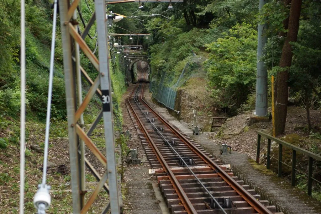
Photo source: Ōyama Cable Line 2012-09-16.jpg (by ume-y, Wikimedia Commons), CC BY 2.0
| Name | Oyama Cable Car (Oyama) |
|---|---|
| Address | 667 Oyama, Isehara City, Kanagawa |
| Hours / Closed | Weekdays 9:00–16:30, weekends and holidays 9:00–17:00 |
| Phone | 0463-95-2040 |
| Map | Open in Google Maps ↗ |
| Official site | Open the official site ↗ |
↑ Back to the comparison table
Tsukubasan (Tsukuba City, Ibaraki)
You can walk up the Miyukigahara course (about 2.0 km, about 90 minutes) and take the cable car down. The cable car takes about 8 minutes from Miyawaki Station to Tsukuba-san-cho Station and costs ¥930 one way and ¥1,860 round trip for adults, and ¥470 one way and ¥940 round trip for children. The ropeway on the Nyotai-san side is also ¥930 one way and ¥1,860 round trip for adults, and ¥400 one way and ¥800 round trip for children.
The Miyukigahara course runs about 2.0 km from Tsukubasan Shrine to Miyukigahara, with an elevation gain of about 610 m, taking 90 minutes up and 70 minutes down. From Miyukigahara to the summit of Nantai-san it is about 15 minutes. The cable car runs 9:20 to 16:40 from December to February and 9:00 to 17:00 from March to November, every day of the year except during the winter inspection.
By train, direct shuttle buses to Tsukubasan run every day from Tsukuba Station (Tsukuba Center) on the Tsukuba Express. By car, the Tsukuba city car park at the cable car side costs ¥500 a day for standard cars (499 spaces).
Checked: cable car fares, ropeway fares, Miyukigahara course, cable car timetable and access on the official Tsukubasan site (Japanese).
| Name | Tsukubasan Cable Car and Ropeway (Tsukubasan) |
|---|---|
| Address | 1 Tsukuba, Tsukuba City, Ibaraki |
| Hours / Closed | Cable car: March–November 9:00–17:00, December–February 9:20–16:40 |
| Phone | 029-866-0611 |
| Map | Open in Google Maps ↗ |
| Official site | Open the official site ↗ |
↑ Back to the comparison table
Hodosan (Nagatoro Town, Saitama)
The ropeway is closed for its regular inspection from December 7 to 26, 2026, so if you go in December, choose early December or the end of the year. The Hodosan Ropeway takes about 5 minutes from the foot station to the summit station, and costs ¥700 one way and ¥1,200 round trip for adults, and ¥350 one way and ¥600 round trip for children. The Hodosan Small Animal Park at the summit is ¥500 for adults and ¥250 for children, and it is closed from December 7 to 31.
According to the operator’s notice of October 30, winter cherry blossoms are in bloom at the summit.
From Nagatoro Station on the Chichibu Railway it is a 20-minute walk to the foot station, and on operating days a free shuttle bus runs between Nagatoro Station and the foot car park. The Hodosan foot car park (about 150 spaces) is ¥500 a day for a standard car on weekdays and ¥700 on weekends and holidays, a 3-minute walk from the foot station.
Checked: fares (multilingual page), access, and the October 5, 2026 notice of the regular inspection on the official Hodosan Ropeway site (Japanese).
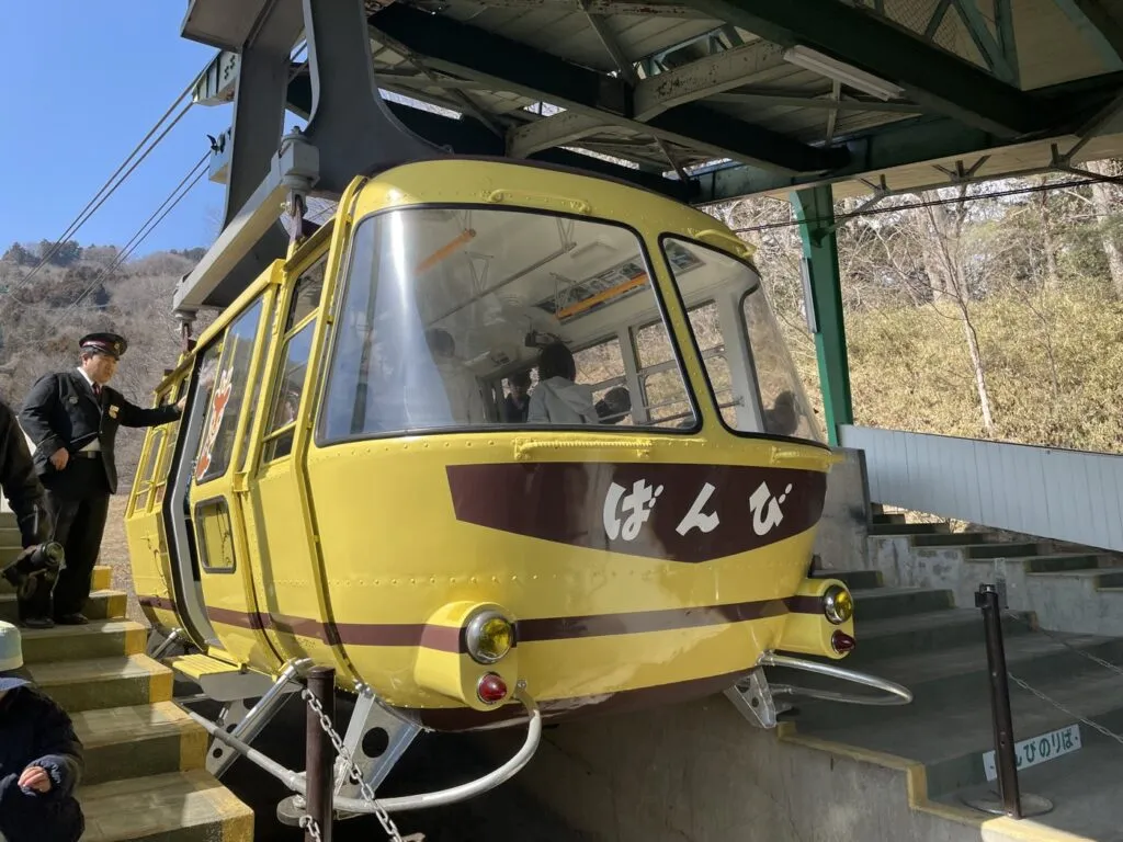
Photo source: 宝登山ロープウェイばんび号 (55111895896).jpg (by Nori Norisa, Wikimedia Commons), CC BY 4.0
| Name | Hodosan Ropeway (Hodosan) |
|---|---|
| Address | 1766-1 Nagatoro, Nagatoro Town, Chichibu District, Saitama |
| Hours / Closed | Closed for regular inspection December 7–26, 2026 |
| Phone | 0494-66-0258 |
| Map | Open in Google Maps ↗ |
| Official site | Open the official site ↗ |
↑ Back to the comparison table
Nokogiriyama (Futtsu City, Chiba)
The ropeway is an 8-minute walk from Hamakanaya Station, and at the top you can walk around Nihon-ji temple (about 1 hour 30 minutes) and the old quarry site. The Nokogiriyama Ropeway takes about 4 minutes one way, and costs ¥650 one way and ¥1,200 round trip for junior high school students and older. It runs 9:00 to 17:00 from February 16 to November 15, and 9:00 to 16:00 in winter, from November 16 to February 15.
From around mid-January every year it is closed for 1 week to 1 month for its annual inspection. On New Year’s Day it starts running at 5:30.
The Nihon-ji grounds (admission is separate) have the Great Buddha, the 1,500 Rakan statues, the Hyakushaku Kannon and Jigoku Nozoki (the “Peek into Hell” lookout), and going around takes about 1 hour 30 minutes. The old quarry where Boshu stone was cut is about 30 minutes on foot one way from the summit station. By car, there is a paid car park (about 200 cars).
Checked: fares and times, sights nearby and facility outline on the official Nokogiriyama Ropeway site (Japanese).
| Name | Nokogiriyama Ropeway (Nokogiriyama) |
|---|---|
| Address | 4052-1 Kanaya, Futtsu City, Chiba |
| Hours / Closed | February 16–November 15 9:00–17:00, November 16–February 15 9:00–16:00 (suspended for inspection from around mid-January) |
| Phone | 0570-035-329 |
| Map | Open in Google Maps ↗ |
| Official site | Open the official site ↗ |
↑ Back to the comparison table
Kobozan (Hadano City, Kanagawa)
You can reach it on foot in about 35 minutes from Hadano Station on the Odakyu Line, and Mount Fuji can be seen from the lookout on Gongenyama. Kobozan Park is made up of 3 mountains: Sengenyama, Gongenyama and Kobozan. The Hadano tourist association introduces the area around the Gongenyama lookout and Sengenyama as among the best places in the city to see Mount Fuji.
For a shorter walk, take the bus from Hadano Station (route Hata 25, bound for “Soya Kobo”) for about 10 minutes to “Kobozan-iriguchi”, then walk about 20 minutes. The city’s walking map also shows the “Kobozan Park and Azumayama course”, which goes down via Azumayama to Tsurumaki-Onsen Station.
Checked: Hadano tourist association page on Kobozan Park (Japanese).
| Name | Kobozan Park |
|---|---|
| Address | Hadano City, Kanagawa |
| Map | Open in Google Maps ↗ |
| Official site | Open the official site ↗ |
↑ Back to the comparison table
Jinbasan (Hachioji City, Tokyo)
It is about 40 minutes by bus from Takao Station to the terminus, Jinba Kogen-shita, then about 90 minutes on foot to the summit. Jinbasan is 855 m high, with a white horse statue at the top. The Hachioji city page says that on a clear day you can see the high-rise buildings of central Tokyo to the east and Mount Fuji to the west.
From the north exit of Takao Station (Keio Line and JR), take the bus bound for “Jinba Kogen-shita” and get off at the terminus.
Checked: Hachioji City page on Jinbasan (Japanese).
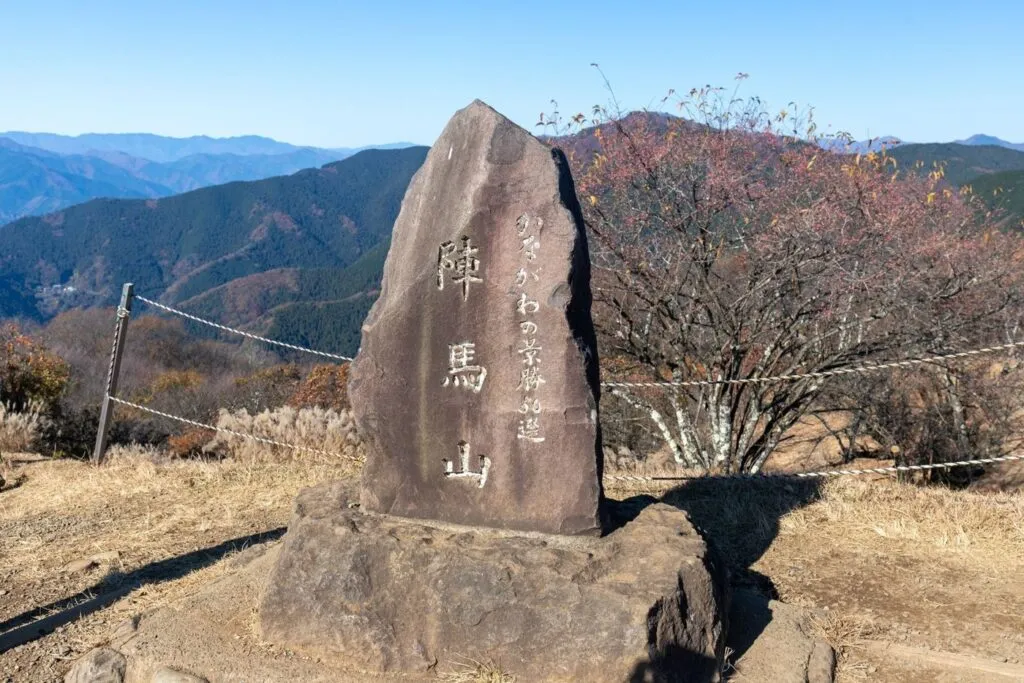
Photo source: 陣馬山山頂20221119-IMG 5304.jpg (by Kurofune, Wikimedia Commons), CC BY 4.0
| Name | Jinbasan |
|---|---|
| Address | Kamiongata-machi, Hachioji City, Tokyo |
| Map | Open in Google Maps ↗ |
| Official site | Open the official site ↗ |
↑ Back to the comparison table
Tenranzan and Tonosuyama (Hanno City, Saitama)
From Tenranzan (197 m) you can keep walking over the Mikaeri-zaka slope to Tonosuyama (271 m). Tenranzan is a low hill in the middle of town, and from the top you can see Hanno, the Kanto Plain and, in good weather, Tsukubasan and Mount Fuji. There are 24 stone Buddhas partway up, and a toilet at the middle level.
Tonosuyama is the highest mountain near the center of Hanno, and the summit has views of the plain and the mountain ranges. The Hanno tourist association’s “Course to explore history in the mountain valleys” (about 10.2 km) passes over both mountains.
There is no car park, so take a Kokusai Kogyo bus from the north exit of Hanno Station on the Seibu Ikebukuro Line to “Shimin Kaikan / Hakubutsukan” or “OH!!! / Tenranzan-shita”.
Checked: Hanno tourist association page on Tenranzan and the course to explore history in the mountain valleys (Japanese).
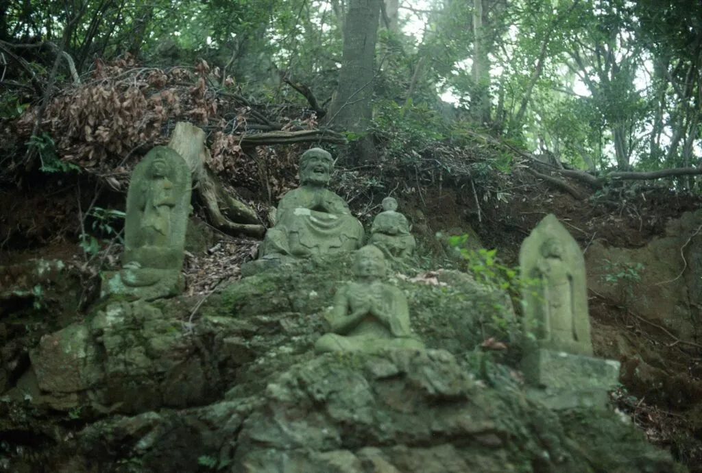
Photo source: 天覧山十六羅漢像/飯能市 – panoramio.jpg (by shikabane taro, Wikimedia Commons), CC BY 3.0
| Name | Tenranzan |
|---|---|
| Address | Hanno City, Saitama |
| Hours / Closed | Free to stroll |
| Map | Open in Google Maps ↗ |
| Official site | Open the official site ↗ |
↑ Back to the comparison table
Hiwadayama (Hidaka City, Saitama)
You can choose your path: a rocky climb up the Otoko-zaka (men’s slope) and a gentler descent down the Onna-zaka (women’s slope). Hiwadayama is 305 m high, and in good weather you can see Tokyo Skytree from the summit. The path splits at the first torii gate. Otoko-zaka takes about 15 minutes to the second torii gate but has rocky sections where you use your hands, and Onna-zaka is a gentle path of about 20 minutes. Hidaka City recommends Onna-zaka for beginners and for the descent.
From Koma Station on the Seibu Line it is about 25 minutes on foot to the trailhead. By car, you can use the Kinchakuda car park (7:00 to 17:00, ¥500 for a standard car, closed December 29 to January 3).
Checked: Hidaka City page on Hiwadayama (Japanese).
| Name | Hiwadayama |
|---|---|
| Address | Hidaka City, Saitama |
| Map | Open in Google Maps ↗ |
| Official site | Open the official site ↗ |
↑ Back to the comparison table
Okusuyama (Yokosuka City, Kanagawa)
It is about 30 minutes by bus from Zushi Station and about 60 minutes on foot from Okusu-Ashina-guchi to the summit. From the Okusudaira lookout just before the summit, you can see Mount Fuji and Enoshima in good weather. From JR Zushi Station or Zushi-Hayama Station on the Keikyu Line, take a Keikyu bus to “Okusu-Ashina-guchi” (about 30 minutes), then it is about 60 minutes to the summit. There is also a course that starts from the “Maedabashi” bus stop.
The rest area, toilet and lookout tower at the summit cannot be used at present, and the toilet is at Okusudaira, about 5 minutes from the summit.
Checked: Yokosuka tourism site page on Okusuyama and the Maedabashi course (Japanese).
| Name | Okusuyama |
|---|---|
| Address | Yokosuka City, Kanagawa |
| Map | Open in Google Maps ↗ |
| Official site | Open the official site ↗ |
↑ Back to the comparison table
Choose by purpose
- A short walk to a summit view with children: Tsukubasan or Hodosan (you can go up by ride).
- A shrine visit together with a mountain walk: Mitakesan or Oyama.
- Walking from a station with no ride fare: Hiwadayama, Tenranzan or Kobozan.
- A solid full day of walking: the summit of Jinbasan or Oyama.
FAQ
Is there a mountain in Kanto where the cable car runs every day in winter?
Yes. The Oyama Cable Car says no closure is scheduled. It can still stop in heavy rain, strong wind or thunder, and Tsukubasan, Hodosan and Nokogiriyama have winter inspection closures.
Which beginner mountains in Kanto can I climb on foot from a station?
Hiwadayama (about 25 minutes on foot from Koma Station to the trailhead) and Kobozan (about 35 minutes from Hadano Station). For Tenranzan, you take a bus from Hanno Station to the foot of the mountain.
Fares and times are subject to change.
Sources
25 pages we checked
- Mitake Tozan Railway: timetable and fares
- Mitake Tozan Railway: model courses
- Mitake Tozan Railway: access
- Oyama Cable Car: timetable and fares
- Oyama Cable Car: access
- Oyama Cable Car: walking and hiking map
- Tsukubasan Cable Car: fares
- Tsukubasan Ropeway: fares
- Tsukubasan: Miyukigahara course
- Tsukubasan Cable Car: timetable
- Tsukubasan: access
- Hodosan Ropeway: fares (multilingual)
- Hodosan Ropeway: access
- Hodosan Ropeway: notice of regular inspection (Oct 5, 2026)
- Nokogiriyama Ropeway: fares and times
- Nokogiriyama Ropeway: sights nearby
- Nokogiriyama Ropeway: facility outline
- Hadano Tourist Association: Kobozan Park
- Hachioji City: Jinbasan
- Hanno Tourist Association: Tenranzan
- Hanno Tourist Association: course to explore history in the mountain valleys
- Hidaka City: Hiwadayama
- Yokosuka tourism site: Okusuyama
- Yokosuka tourism site: Maedabashi course
- Japanese version of this page (日本語版)
Checked with official pages on November 1, 2026 (Japan time).